Tellico ORV Area |
||
|---|---|---|
| , |
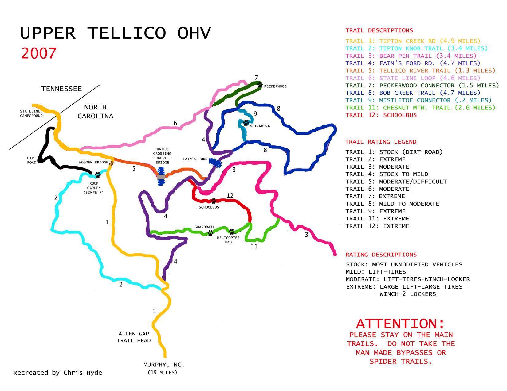
Description: Upper Tellico ORV Area Info The Upper Tellico ORV Area is located in the Nantahala National Forest near Murphy, North Carolina in Cherokee County. Murphy is located in the southwestern part of the state where North Carolina, Tennessee, and Georgia all come together, and at the junction of Hwy 19/74 and Hwy 64. The Upper Tellico ORV Area is famous for some of the best 4x4 trail riding in all of America. Names like Guardrail, Helicopter Pad, Slick Rock and School Bus all conjure up visions of rock piles, steep hills and off camber ascents to challenge offroaders of all experience levels. Ratings; Trails are rated from 1(easiest) to 10 (most difficult). Keep in mind that rain or snow can increase the ratings at Tellico by two to three points. 1-3 feature trails with obstacles that are easy to navigate. In optimum weather conditions, some of these trails may not require the continual use of four-wheel drive (4WD). 4-7 trails are moderately demanding and require 4WD. You may encounter a wide variety of challenges, including mud holes, boulders, and stream crossings. 8-9 ratings indicate that the likelihood of getting stuck is considerably higher. Mud holes here may be deep and rock climbing will be more arduous. There is a chance for parts breakage and body damage on these trails. 10 is reserved for the rocky, off-camber, most difficult obstacles. Rollovers, breakage and body damage is to be expected here. Trail #1. Rated Easiest. We agree and give this one a 1. This is the rough dirt road running through ORV area from NC to TN. Even though this is the easiest trail in the ORV area, you still need to pay close attention while driving. One weekend last year (2000) in Sept., two different vehicles ran off the side and rolled down the mountain. It is very steep with nothing to stop you, except a tree if you're lucky. Trail #2. Rated Moderate. Definately WRONG! The bottom of 2 is known as the "Rock Garden" and is a solid 8-9 with a couple of real nasty ledges. Which ledge is the toughest depends on what the weather has been and how much traffic the trail has had. Due to erosion and rocks being moved (or stacked) it's hard to say which ledge you'll have the most difficulty with. Be assured though, both are fun! This was the site of SFWDA's Rock Crawling contest during the 2000 Dixie Run, and none of the BIG DOGS completed the course without winching. The upper part of 2 is known as the "Bobsled Run" and is a 7-8. Trail 2 is arguably the "Most Difficult" trail now at Tellico. Trail #3. Rated Moderate. We believe that it's easier and give it a rating of 2-3. Trail 3 offers a nice view of the bottom of Trail 12 and the backside of Trail 11. Trail #4. Rated Easiest. We disagree and give it a 4. It has a nice creek crossing and connects to Trail 6; together they run across the entire area and are used to access most other trails. Trail #5. Rated Moderate. Challenging level 5&6 with some ledges and rocks. The creek crossing that used to be known as "Rough Crossing" has had the obstacles removed that made it a challenge. A bridge is also going to be built across it to reduce the amount of sediment washed into the stream. Trail #6. Rated Most Difficult. Interesting fun trail, but definitely not in the same league as Lower 2, 9, 11, or 12. It's more of a hard moderate and we rate it a 6-7 going up and a 5-6 coming down. Trail #7. Rated Moderate. Most of the trail is an easy 2-3 with the exception of one big rock ledge that is a 7-8 and has been the scene of many rollovers. This ledge used to be pretty much impassable to all but the those with extra long wheelbases. However, some recent "trail work" has been performed here and now shorter vehicles can navigate it. Trail 7 is also known as "Peckerwood". Trail #8. Rated Moderate. We agree and give it a 4-5. Very nice loop trail with some loose rocks that provide excitement. Trail #9. Rated Most Difficult. Known as "Hard Rock" going up and "Slick Rock" coming down, either way, this trail provides plenty of excitement. The approach to the rock runs right up a creek bed with lots of big, loose muddy boulders that get shifted around each time someone goes up. Steering linkage damage and tires coming off the rim happen quite frequently here. There is no getting around Hard Rock, so when you reach this point on Trail 9 you are committed. The rock has a very smooth surface, is about two stories tall, and has a natural spring at the base to ensure that it's always muddy and wet. There are three lines that can be taken to ascend the rock, you can hang either far left for the easiest approach; far right and it will be an 8-9 climb, or you can attempt the middle and take your chances! This is a favorite place for the locals to gather and watch the show and rollovers are quite common. The fun is not over when you get to the top of Hard Rock either, as there is still a couple of good ledges awaiting you before you run into Trail 8. Trail #10. Rated Moderate. ATV and motorcycle use only. The only time that we've been on the trail was to haul an injured ATV rider out of the woods in our Jeep. We've not seen the entire trail, but understand it has some tricky sections. Trail #11. Rated Most Difficult. We give it an 8-9 going up and a 10 going down. The two hard spots are known as "Guardrail" a.k.a. "Half-Way Rock", and "Helicopter Pad". Guardrail is a huge rock face that has a guardrail attached to some trees to keep vehicles from rolling down the mountain. Again there is no "go around" here, so you either have to climb it or pull cable. Shortly after getting up Guardrail you are faced with the decision of hopping on the Helicopter Pad or taking the bypass to the left. If you choose to go up the Pad, pay close attention to the rock outcropping on your left. If your not careful (or lucky) it will leave you with a souvenir all the way down the drivers' side of your vehicle. Trail #12. Rated Most Difficult. Known as "School Bus" and it is a good 8-9 trail up the mountain. It is a long, steep, rutted hill climb, with many ledges and tight turns. Once you start there is no letting up until you reach the top. Coming down is a lot of fun too, but if your rig has an automatic, disc brakes are highly recommended. This is no place to be in a hurry! For years School Bus was considered the toughest trail at Tellico, but the big ledge at the top has now been smoothed out, so... our vote for the most challenging trail is Lower 2. Come ride them both and decide for yourself! Legalality: This trail is open to the public. The Tellico ORV Area is a fee access area. The cost is $10.00 per day/vehicle payable at the Forest Service entrance station. The station is operated on the honor system, so you will need to have correct change (they do accept checks). The money collected here is used to keep the trails open for all of us. Southern Four Wheel Drive Association (SFWDA) maintains the Tellico ORV trail system and contributes thousands of dollars and man-hours to this endeavor each year. Please do not litter or drive off the established trails. This is a dry county and it is against the law to have alcoholic beverages in your vehicle within the ORV area. From Murphy, NC; From the McDonalds in Murphy on Hwy 64, turn north (left) onto Hiwassee St and go to the first traffic light. Turn left at light onto Tennessee St and leave town, the road becomes Joe Brown Hwy (there is a couple of places along here to buy gas) continue for 2.8 miles until you come to a blinking caution light. Turn right at caution light and continue for approx. 5.5 miles and turn right onto Davis Creek Road. Pavement will end soon and the Forest Service entrance station will be on your left. Trail #1 starts here and continues through the ORV area and turns into River Road at the NC/TN state line. From Sweetwater, TN; Take Hwy 68 East at exit #60 off I-75 to Tellico Plains, TN. Just past the Hardee's restaurant in Tellico Plains (last chance for gas), turn left onto Hwy 165, which leads through downtown. Once through downtown, the Tellico River comes into sight. Turn right onto River Road and from this point on, always follow the river! Follow the signs to Bald River Falls .If you do not see the river for a few hundred yards next to the road; you have made a wrong turn. Most roads beyond Tellico Plains are not well marked. Bald River Falls can be seen on the right when passing across a bridge. Continue to follow the river and you will eventually come to the infamous Green Cove Motel. If you happen to get lost, ask a local for directions to Green Cove. The TN/NC state line is about 5 minutes past the motel and when the pavement ends you are on Trail #1 in the ORV area. Requirements: Need to have: 4WD, Recovery Strap, Tow Hooks Good to have: Winch, Lockers, CB
|
|
| Latest Members |
|---|
|
|---|

| > |
|---|